
Wirral regeneration – The changes coming our way in the months ahead
Regeneration projects across Wirral are changing the borough, already bringing noticeable differences to the skyline and with even more dramatic transformations soon to come.
From new homes and offices at Wirral Waters and in Birkenhead town centre to clearing unwanted and derelict sites ahead of new developments, work is powering ahead to enhance much loved and key locations such as Woodside – there is a lot more change about to happen.
This follows the adoption of Wirral’s brownfield only Local Plan underpinning the regeneration of the borough which is set to continue moving ahead at pace focusing bringing forward new homes and boosting town centres in Birkenhead, New Ferry, and Liscard.
Leader of Wirral Council, Cllr Paul Stuart, said:
Under my leadership in the last couple of years we have seen the much-talked-of changes to our borough becoming a reality, spades in the ground, new homes created and office buildings opening and infrastructure improvements coming through.
None of this is easy, and with changes of such scale there are inevitable temporary inconveniences which we have tried hard to help people through, but we know that in the long run this will mean we are preparing our borough for the future.
And this pace of change shows how far we have come already, highlighting our way forward in the coming months and years, as we deliver real and meaningful developments and widespread improvements across Wirral, bring forward the transformation which will help not just us now, but for future generations.
Below is a quick guide to a number of major schemes which are expected to be seeing dramatic change in the not too distant future.
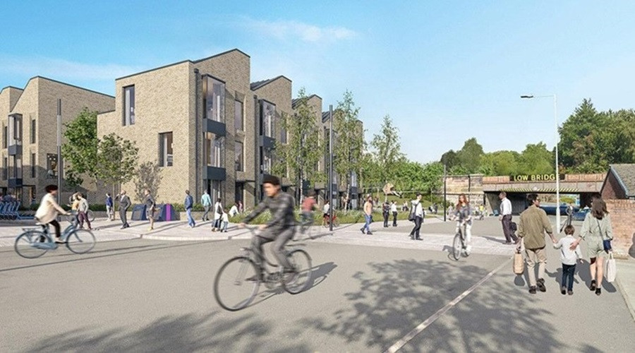
Hind Street
What’s happening?
Adjacent to Birkenhead is the Hind Street scheme which the council is working alongside developer Ion to deliver hundreds of new homes.
What does it look like now?
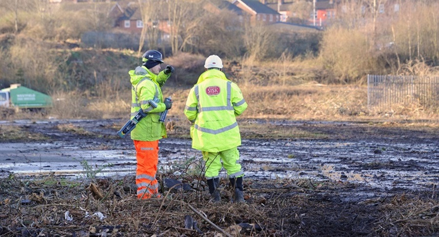
In February diggers arrived on the site of the major new urban village set to be built next to Birkenhead town centre.
Clearance is currently underway as work begins on preparing the site for the massive redevelopment coming there. Homes England, the government’s housing and regeneration agency, has agreed a £29 million investment in the project, with a similar commitment from the LCRCA bringing the investment to £52million giving an indication of the scale of the project which will first need the vital infrastructure works to unlock the site and deliver the first 633 homes.
How will it change?
The planning consent for Hind Street allows for development of a new neighbourhood with up to 1,600 new homes, a new park along the old Dock Branch railway line, new and improved facilities for pedestrians, cyclists and public transport, along with the development of other commercial and community facilities.
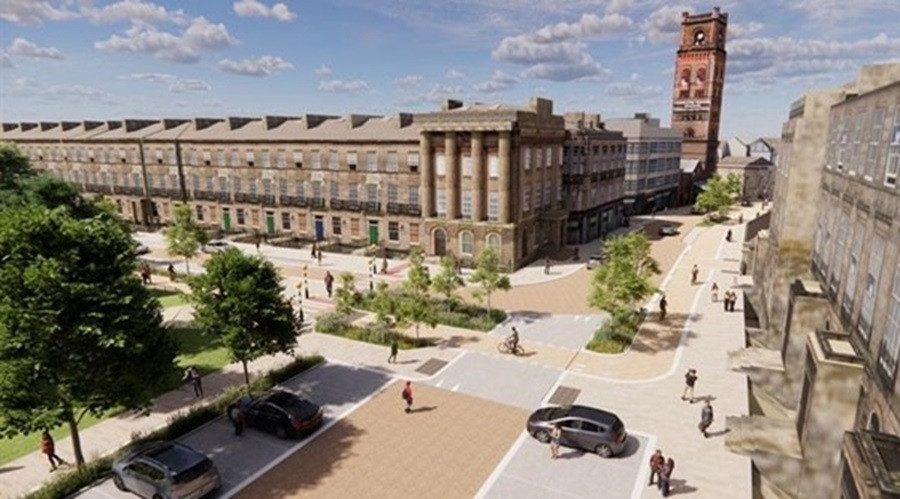
Birkenhead Town Centre
What’s happening?
A major revamp of Grange road pedestrianised shopping area alongside major improvements on Conway Street, Europa Boulevard and car park,Charing Cross and Grange Road West are part of this joined-up approach to delivering a town centre fit for purpose. Charing Cross junction will have improved crossings and paving installed while a trial one-way system will be installed along part of Grange Road West. In addition a new electrical substation is being built to ensure there is sufficient power supply for the planned new homes and developments.
What does it look like now?
Visitors to the town centre will see considerable works being undertaken across Grange Road, Charing Cross and Conway Street as well as Europa Boulevard. Measures are in place to minimise disruption as far as possible but these work will be continuing for some months yet.
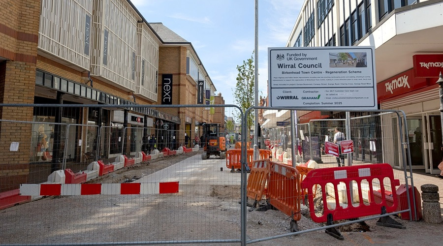
How will it change?
The revamped town centre is at the heart of much of the wide ranging plans for regeneration across much of the borough and will see Grange Road modernised and Charing Cross and Grange Road West improved for shoppers.
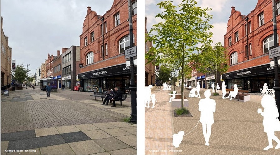
Conway Street and Europa Boulevard will also be made fit for purpose and more accessible to pedestrians and cyclists, while opening up that part of the town centre for future development and improvements as outlined in the Birkenhead town centre masterplan.
Birkenhead Market/St Werburgh area
What’s happening?
Birkenhead's historic and much-loved market is preparing to move as part of wider plans to secure its future and play its vital role in helping to breathe new life into the town centre. It is at the heart of the masterplan for the St Werburgh area which was developed to help with attracting more people into the town centre and increasing leisure and residential opportunities who also better linking the central shopping area to Argyle Street and the distinctive Hamilton Square Conservation Area.
What does it look like now?
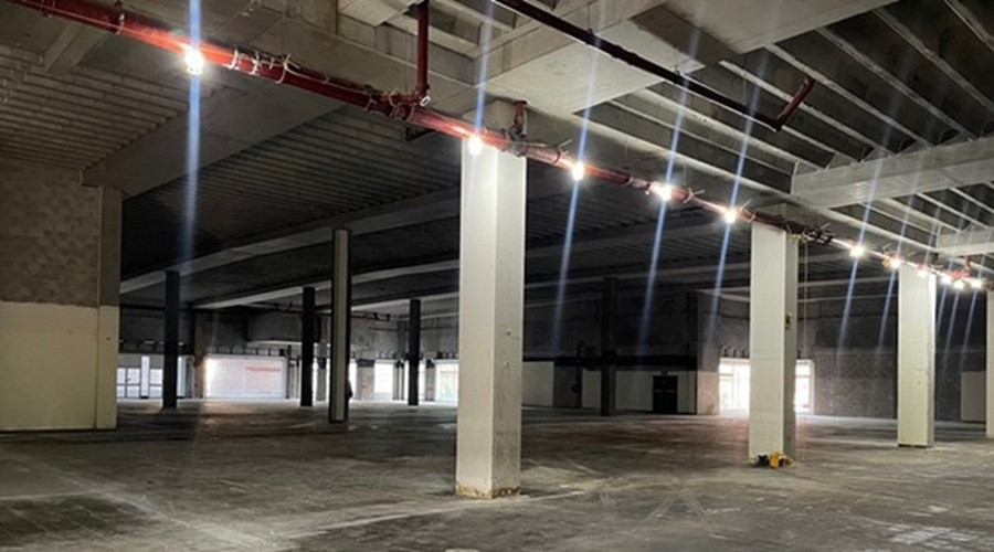
The “soft strip” demolition of the unit at Princes Pavement was completed late last year, opening the way for the fit-out work starting for the new market. In March (2025) the council announced the appointment of a contractor to bring the new Market closer to the construction phase and finalise the design of the new Birkenhead Market. The demolition of the former House of Fraser store has opened up a key site for housing and work is continuing on this.
How will it change?
The new market will be adjacent to the existing bus station in the former Argos building in part of the Pyramids & Grange shopping centre, which has been acquired by the council.
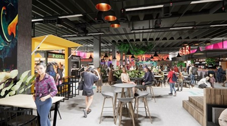
Some images giving an indication of how the new market could look have been released recently and updates on this and other St Werburgh sites will continue over the coming months as the projects progress.
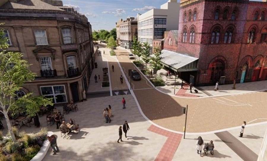
Hamilton Square/Argyle Street
What’s happening?
The final round of consultation has been taking place on proposed improvements to roads and public spaces around Argyle Street, Hamilton Square and Woodside to improve accessibility and better connect Birkenhead Town Centre with its waterfront. The proposed works include highway, active travel and public realm improvements including the area from and including the Argyle Street / Conway Street roundabout to Woodside Ferry Terminal (via Hamilton Square / Hamilton Street). The changes will support the £20 million-plus transformation of a key part of Birkenhead and Wirral’s Waterfront.
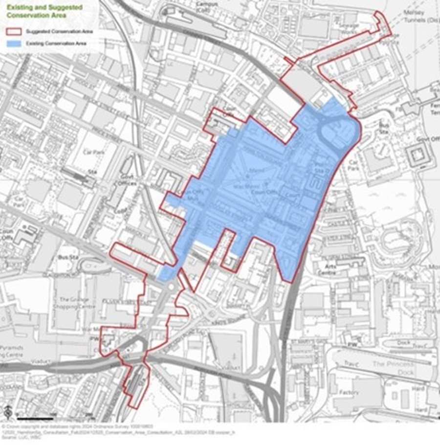
In addition the council has been asking people about proposals for the Hamilton Square Conservation Area Regeneration Plan and the proposed extension of the Conservation Area boundary, with proposed changes which would see this extended.
What does it look like now?

How will it change?
The proposed road changes will support the £20 million-plus transformation of a key part of Birkenhead and Wirral’s Waterfront and complement the recent investment in helping improve shop fronts on Argyle Street. This saw the implementation of the Argyle Quarter Commercial Property Improvement Grant Scheme – funded by the Liverpool City Region Combined Authority through the city region’s UK Shared Prosperity Fund (UKSPF) allocation – which had invited businesses within the area to bid for funding. The purpose was to help improve the look of the area while retaining heritage features and support business growth, contributing toward the ongoing regeneration of Birkenhead as a whole. 10 businesses were successful in securing funding, and work has now been completed, giving the area a fresh new look which businesses are already reaping the rewards of.
If the Conservation area is extended, the area would be continued along Argyle Street up to and including Birkenhead Central Station and extended north to include around the Pacific Road area, as part of wider efforts to conserve the historic architecture.
The changes to the roads around Hamilton Square and Argyle Street could see, for example, a segregated bi-directional cycleway running along the west side of Hamilton Square from Price St to Cleveland St, turning onto the south side of Hamilton Square North and then onto the east side of Hamilton St; a Toucan Crossing from the front of Hamilton Square Station to Bridge St.
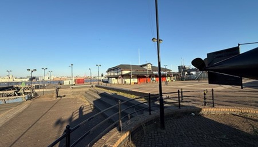
Woodside
What’s happening?
Plans were recently submitted supporting the £20 million-plus transformation of this key part of Wirral’s waterfront and maximising its position overlooking one of the most iconic locations in the world.
The planning application for Woodside Culture Park and arrival plaza aims to maximise the promise of the immediate area around the terminal for the world-famous Mersey Ferry and capitalise on the unique attributes of the location to create a major attraction.
The wider revamped site will also form a key gateway into the rest of Birkenhead connecting major regeneration already underway across the town while better bringing together Woodside Ferry Terminal, Hamilton Square and the wider town centre.
What does it look like now?
The planning application site area extends to approximately 0.66 hectares and the proposed development includes:
• Change of use of the current car parking adjacent to the Woodside Ferry Terminal to a high-quality events plaza with flexible spillover space to the north east;
• The partially boarded area of water to the north is to be converted to a safe place for children’s play. A small section closest to the river wall, will be protected by fencing and be retained as open to incorporate and showcase heritage features;
• The outdoor space previously occupied by the Woodside Market during and post COVID will accommodate attractive new urban parkland, greening and a sustainable drainage system to further soften the aesthetic of the area.
How will it change?
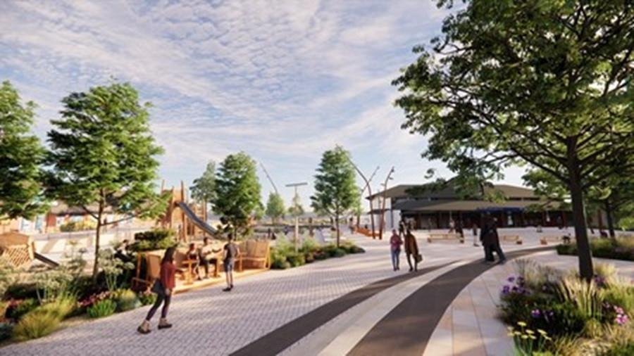
The Birkenhead Waterfront was identified as a key location to support the wider push for regeneration within the recently adopted Woodside Masterplan, Birkenhead Regeneration Framework and the emerging Local Plan. The aim of the initial work is to make the waterfront area far more accessible, better for pedestrians, cyclists and those on public transport as well as creating a visitor destination with worldclass views across to Liverpool and delivering on the Council’s aims to open up brownfield development opportunities.
The application follows the commission of a design team to identify highway and public realm improvements around Woodside waterfront and surrounding areas to look at how these areas could be redesigned to be more attractive, more accessible, and better connected. This included analysis of the previous feedback received from the community when comments were collected in relation to the earlier designs. This infrastructure project alone will see in excess of £20million invested and coincides with the £10million new ferry pontoon scheme being delivered by Merseytravel / Ferries.
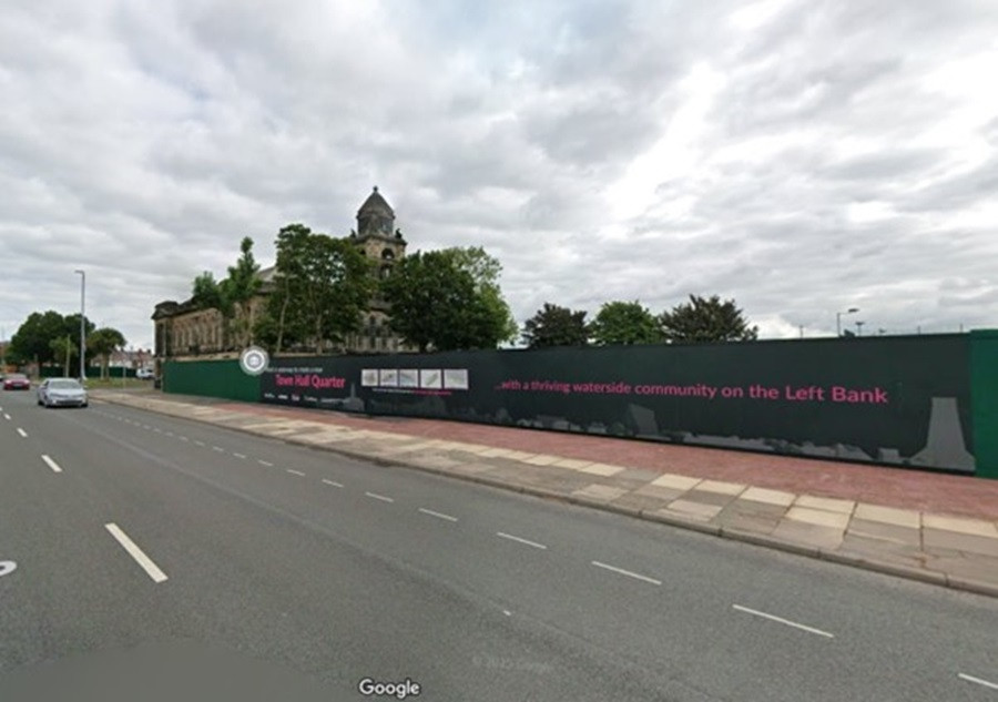
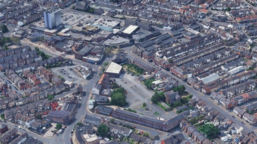
Wallasey town hall quarter
What’s happening?
The Council’s Draft Local Plan identified Seacombe as a priority area for regeneration and the Wallasey Town Hall Quarter and a detailed masterplan has been developed to help shape the future of the area.
What does it look like now?
The north and south annexe buildings either side of Wallasey town hall were demolished in 2024 with the assistance of the Brownfield Land Release fund and significantly changing the look of the area. The next stage will be working with a developer to bring new and affordable housing to the sites as part of the progress to deliver on the Wallasey Town Hall Quarter Masterplan.pdf
How will it change?
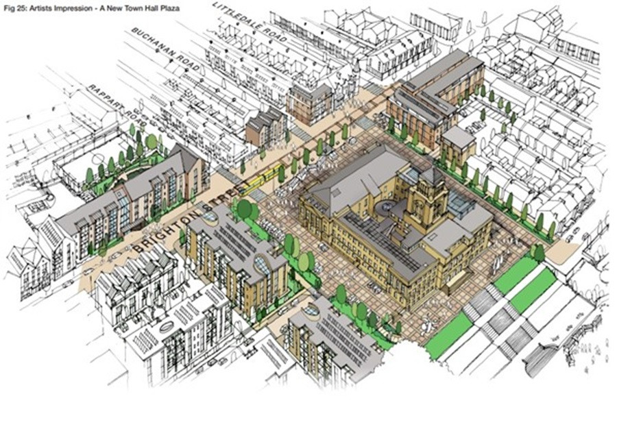
This Masterplan aims to create the opportunity to develop a sustainable vibrant 'Town Hall Quarter' with Wallasey Town Hall as the centrepiece, intending to kick start investment and initiate wider systematic transformation of the Seacombe River Corridor area around a remodelled Town Hall Quarter with a centralised plaza as a focal open space around the Town Hall. It would also see a phased and structured programme of mixed redevelopment (brownfield site first approach) with the potential to deliver 368 new homes.
Liscard
What’s happening?
The regeneration of Liscard is about to take a major step forward, as contractors start on site next week to knock down the former municipal building at Seaview Road, making way for affordable housing and follows a decision by councillors to progress delivery of the Liscard Levelling Up Fund 3 programme as a standalone scheme, following a pause in the project due to the 2024 election.
What does it look like now?
The last several years have seen a number of steps, such as the Liscard Business Grants scheme in which 33 independent businesses were assisted to improve shop fronts, security measures and customer facilities. The Liscard Community Grants Programme saw nine local organisations delivered a range of cultural, creative, youth engagement and community investment activities in and around the town centre.
New CCTV, upgraded street lighting, and other safety features have also been installed along Liscard Way to help reduce vandalism and anti-social behaviour, but there remains more to do and the council has secured £10.78m of funding for Liscard from the UK Government’s Levelling Up Fund Round 3, matched by £1.2m of council funding to support this.
How will it change?
The Liscard Neighbourhood Framework: An Integrated Masterplan was approved in November 2021 as the regeneration strategy for Liscard. Using the Levelling Up funding the work will now focus on the public realm improvements outside McDonalds, unlocking high quality residential development at the Seaview Road car park site to meet local housing needs; and enhancing community facilities in the town centre.
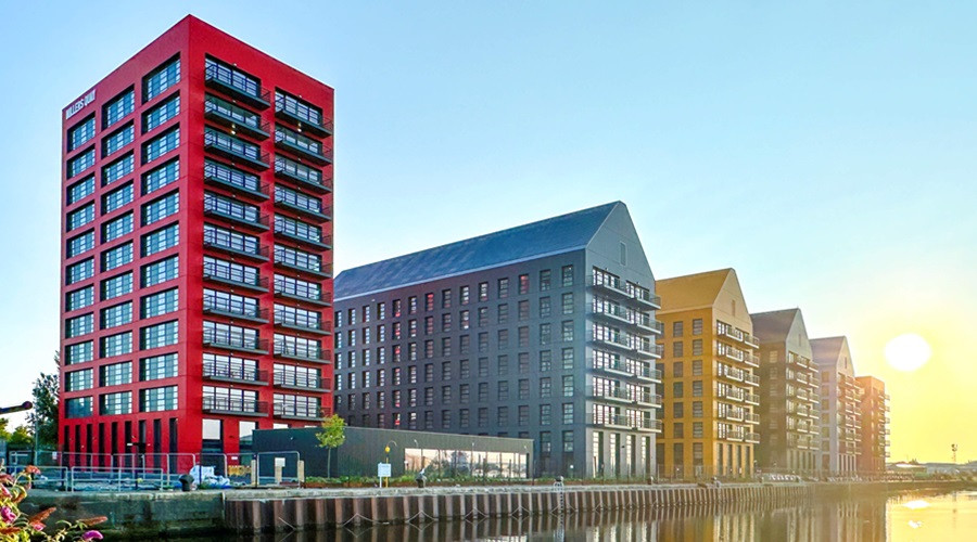
Wirral Waters
What’s happening?
Wirral Waters is one of the largest and most exciting regeneration project in the UK. The Wirral Waters site has planning consent for thousands of new homes and millions of square feet of mixed use floor space. So far it includes residential – featuring new homes and office developments and not forgetting Wirral Met College which has a site there.
What does it look like now?
Following on from the redeveloped historic East Float Quay apartments in the Northbank neighbourhood maximising the waterside location on the docks at Wirral Waters, Millers Quay is the latest development to have completed, finishing this year and providing 500 highly sustainable one- and two-bedroom waterfront apartments. The development, which includes100 affordable new homes, was supported by Wirral Council to ensure it could go ahead. It follows the Redbridge development of new houses on the waterfront as well as high quality office accommodation.
How will it change?
While much development has already taken place the Wirral Waters site still holds much potential. Recent planning applications include additional homes at Redbridge Quay and a new health and wellbeing fitness complex by David Lloyd near Wallasey Bridge Road, while plans for a new Sainsburys next to Millers Quay were recently approved.
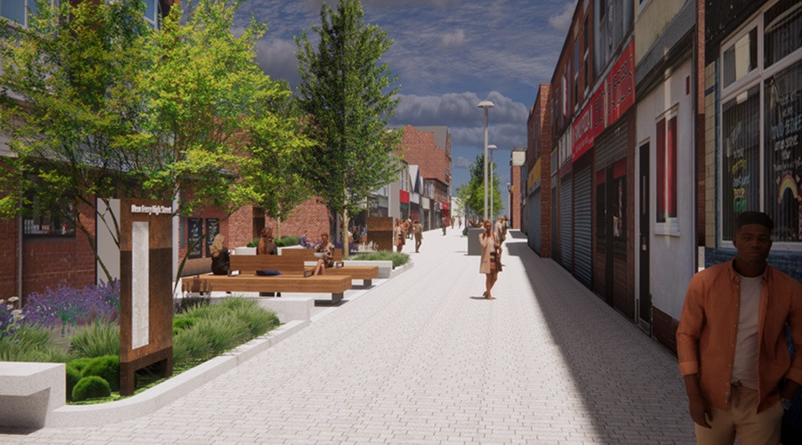
New Ferry
What’s happening?
Members of the Economy, Regeneration and Housing Committee voted in March to re-direct nearly £3.5m of funding to the New Ferry plans to allow the scheme of works to improve Bebington Road to be delivered to the highest standards having previously been pared back to a funding shortfall.
The amended scheme incorporates improvements to address road safety concerns, anti-social behaviour issues and provides an enhanced and appealing environment which will benefit the town’s retail centre. These revisions to the scheme received strong support in a consultation exercise held in September 2022.
What does it look like now?
Since January demolition works have been taking place to take down the former Co-op supermarket, the derelict retail properties that backed onto Woodhead Street from New Chester Road and the former public toilets. This has now concluded and the cleared site is getting ready for the second and final part of the regeneration of the area.
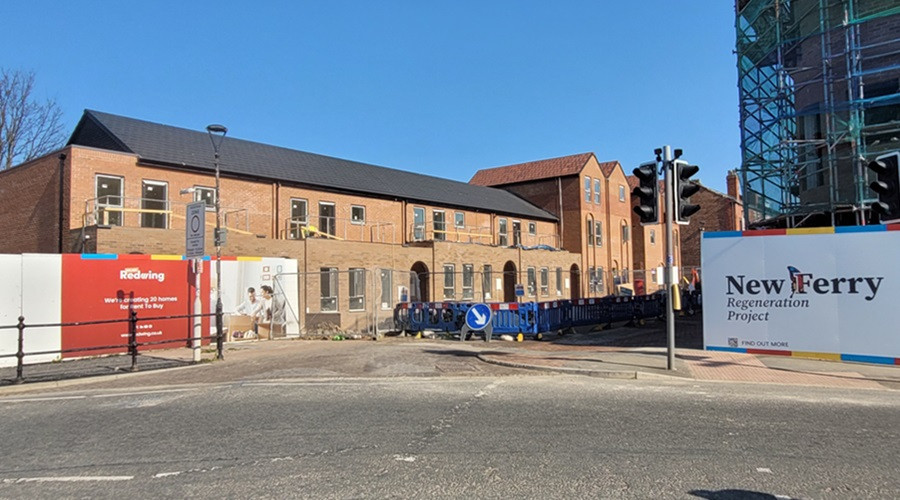
How will it change?
The works currently being undertaken by Regenda will provide 77 affordable new homes in New Ferry, while Wirral Council also has significant public realm improvements planned. The first phase of the housing redevelopment works will be completed in July, providing 34 new apartments for rent. The second phase of 33 new homes and 10 apartments are expected to start later on this year.
The demolition work and the additional funding being provided for the New Ferry public realm improvements has paved for the way for better, public car parking provision on Grove Street, with direct access to the businesses on Bebington Road. Work on the car park is set to begin in July 2025.
And the rest:
And that’s not all – with plans for hundreds of new homes near the river at Bromborough Wharf plus housing and commercial development at Moreton also in the pipeline. A masterplan for New Brighton identifies considerable opportunities for building on the massive investment the seaside town has enjoyed in recent years, and this is all underpinned by Wirral’s Local Plan, recently fully adopted by the Council and which shows how thousands of new homes can be delivered while also protecting the borough’s Green Belt.