
Have your say on proposed improvements to roads around Woodside area
[Updated April 8]
The final round of consultation is now underway improvements to roads and public spaces around Argyle Street, Hamilton Square and Woodside to improve accessibility and better connect Birkenhead Town Centre with its waterfront.
This consultation, which can be completed via the Council’s Have Your Say page, includes Traffic Regulation Orders required to support the changes being put forward.
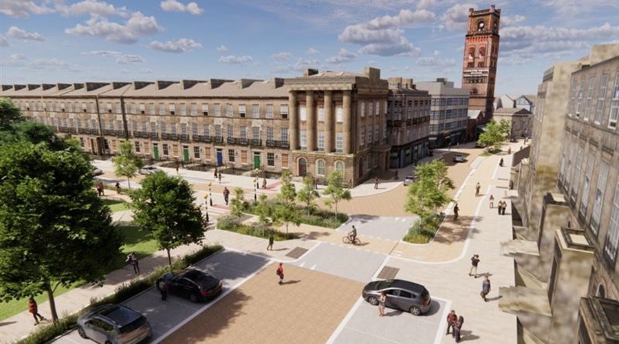
The proposed works include highway, active travel and public realm improvements including the area from and including the Argyle Street / Conway Street roundabout to Woodside Ferry Terminal (via Hamilton Square / Hamilton Street).
The changes will support the £20 million-plus transformation of a key part of Birkenhead and Wirral’s Waterfront.
A planning application recently submitted for Woodside Culture Park aims to maximise the setting of the immediate area around the ferry terminal for the world-famous Mersey Ferry service and to capitalise on the unique attributes of the location – overlooking Liverpool’s iconic skyline - to create a major attraction.
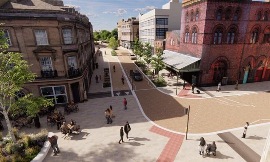
This statutory consultation is seeking views on the work to ensure improved connections from the Woodside Waterfront location to Birkenhead town centre and vice versa. It will better integrate major regeneration already underway across Birkenhead alongside framing the Woodside area in particular to become a world class neighbourhood in the medium to long term in line with the aspirations of the recently adopted Woodside Masterplan.
There have been previous rounds of consultation on this scheme which has supported the design development of the project, and full details of these consultations can be found in the lifecycle section on the Council’s Have Your Say web page.
In this final statutory phase of consultation, feedback is being sought on the proposals which include highway, active travel and public realm improvements to Woodside Waterfront and its surrounding areas, covering the area from and including the Argyle Street/ Conway Street roundabout to Woodside Ferry Terminal, including on the Traffic Regulation Orders required to implement highway changes proposed for the area. These Traffic Regulation Order elements are summarised below, and to make the technical proposal plans easier to read, the changes have been split into two parts for each section of the proposed changes:
- Part A displays changes that proposed as a Traffic Regulation Order (TRO). The council must consult on any TROs and consider any objections raised by the public.
- Part B represents notice of proposal for additional changes proposed but which are not part of a TRO amendment.
Argyle Street (Conway Street to Hamilton Square South Section)
Part A (TRO)
- Parking and Loading Restrictions: contained throughout the plan area.
Part B (additional changes proposed)
- Zebra crossings: in two locations on Argyle St, one at the south side of the junction with Marion St and the second on the north side of the junction with Lorn St.
- Raised tables: A raised table is used at crossing locations and at junctions to calm traffic and provide a safer, more convenient crossing points for pedestrians by creating a continuous footway. These are located on Argyle Street at the junctions with Market St / Lorn St, Hinson St, Marion St, Dacre St.
- Segregated Bi-directional Cycleway at Conway Street: running along the west side of Argyle St from Conway St to Price St.
Hamilton Square (South Section to Bridge Street)
Part A (TRO)
- Parking and Loading Restrictions: contained throughout the plan area.
- One Way street along Hamilton Square (North), Hamilton Street, Bridge Street.
Part B (additional changes proposed)
- Zebra Crossing: on Hamilton Square North (to the west of Hamilton St).
- Segregated Bi-directional Cycleway: running along the west side of Hamilton Square from Price St to Cleveland St, turning onto the south side of Hamilton Square North and then onto the east side of Hamilton St.
- Shared Pedestrian and Cycle footways: located around all four corners of the Price St and Hamilton Square junction, Cleveland St and Hamilton Square junction and on Hamilton St west (outside of Hamilton Sq Station).
- Bus Stop: being relocated from Argyle St west (between Market St and Price St) to Hamilton Square west.
- Toucan Crossing: to cross in a north easterly direction from the front of Hamilton Square Station to Bridge St.
- Bus Stop: on Bridge Street (Rail Replacement Only).
Gyratory (Bridge Street to Woodside Ferry Approach)
Part A (TRO)
- Parking and Loading Restrictions: contained throughout the plan area.
- Restrictions for general vehicles introduced to limit access from Canning Street and Shore Road onto the existing Woodside Gyratory.
- Restricted Access for general vehicles introduced to limit access along Woodside Ferry Approach.
- One Way Street along Woodside Ferry Approach (New Road): new bus turnaround area (adjacent the U-Boat).
- Pedestrian and Cycleway Zone: An area will be designated for the use of pedestrians and cyclists on the northern side of the Gyratory. To see the exact area affected, please refer to the proposed prohibition of driving area in the plan document. Note- the zone may be occasionally used by vehicles under exception (for emergency services / servicing local buildings etc).
Part B (additional changes proposed)
- Bus Stops: Two on Bridge St (in both directions) and the New Woodside Ferry Approach bus turnaround area (adjacent the U-Boat).
- Toucan Crossings: one on Chester St and another between Bridge St and Canning St.
- Segregated Bi-directional Cycleway: Contained throughout the plan area.
- Shared Pedestrian and Cycle footways: Contained throughout the plan area.
Further to this you will also find some general arrangement drawings on the website that show an overall version of the changes.
Feedback on these proposals can be provided until the 27 April by completing the short survey at the Council’s Have Your Say site here. There is also an option to view the plans on request at Birkenhead Town Hall from 2 April to 27 April, or to write to the council at PO Box 290, Brighton Street, Wallasey, CH27 9FQ. Feedback from the consultation will be reported to the Council’s Environment, Climate Emergency and Transport Committee in Summer 2025 to support decision making in relation to the scheme, in line with the Council’s constitution.
This project is not funded by council tax, but from various external sources including the Towns Fund and Levelling Up Fund via the UK Government, alongside Active Travel funding from Liverpool City Region Combined Authority. This project is also part of the wider programme of regeneration activities in Birkenhead as part of the 2040 Framework.
This is a statutory consultation. The route also includes the amendment to a TRO (Traffic Regulation Order). The Council must consult on changes to any TROs and consider any objections raised by the public / stakeholders. The statutory process sets out that the consultation must be no less than 21 days and this consultation will run for longer than this timeframe.
Please note the plans and documents may not be accessible for people with disabilities, users of assistive technology or mobile phones. If you need an accessible copy of these documents, or help reading the documents, please contact us at activetravelprojects@wirral.gov.uk.