
In focus: St Paul's and Church Road, Wheatland Lane + Mainwaring Road

Wirral Council is running a consultation on a significant regeneration project aiming to connect Birkenhead and Liscard with better travel facilities.
The scheme is the first part of the Liverpool City Region Local Cycling and Walking Infrastructure project (LCWIP) proposed to be delivered in Wirral, and aims to encourage more people to walk, cycle or wheel for short journeys along a redesigned route.
So what are the proposals? Here, we take our fourth look at sections along the route.
In focus: St. Paul's Road and Church Road
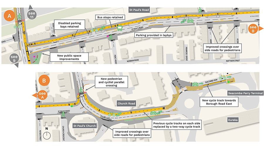
St Pauls Road will be reduced in width to allow a new two-way cycle track to be provided on the north side. Parking will be provided in laybys with all disabled parking spaces and bus stops retained. Two-way vehicle movements will still be possible along St Pauls Road.
Footways will be improved by raising crossings across side roads. A new pedestrian and cyclist parallel crossing will be provided over Church Road with the existing cycle lanes replaced by a new two-way cycle track separate from traffic.
In Seacombe View, the existing pedestrian and cycle routes will be improved by extending the raised crossing and providing a cycle track on the existing island for cyclists heading towards Borough Road East. Cyclists heading towards Seacombe Ferry terminal will use the existing one-way road. Some small shared spaces are required to allow access across roads.
In focus: Wheatland Lane
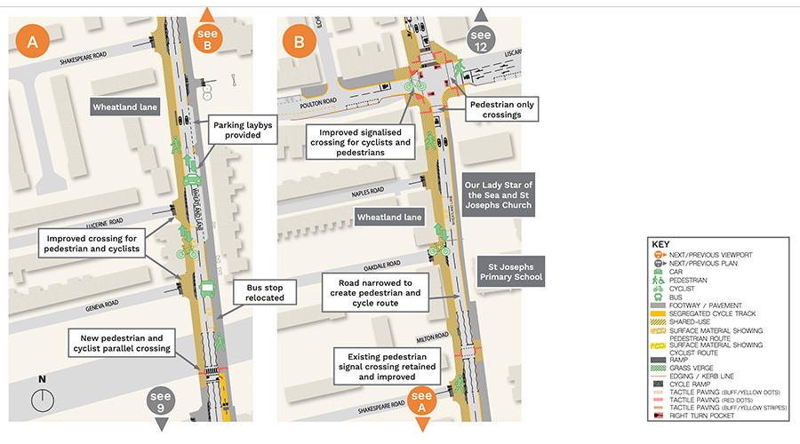
A new two-way cycle track will be provided on the east side of Wheatland Lane, continuing the route from St Pauls Road.
A new pedestrian and cyclist parallel crossing will be provided to allow the route to cross to the west side of the road where there is more room. From this point the route continues as a pedestrian and cyclist shared space as far as the Poulton Road junction. The shared space will include raised crossings over side roads an measures to help keep vehicle and cycle speeds low.
A number of parking spaces will be provided in front of the houses on the east side of Wheatland Lane and the bus stops will be retained, with some minor changes to location. In front of the school the existing pedestrian crossing will be retained and made easier to use due to the road being narrowed.
Two-way vehicle access will be retained along the road although parking will not be permitted other than in laybys.
At the Poulton Road/Mainwaring Road junction, improvements will be made to allow pedestrians and cyclists to use the west side of the junction, with pedestrians only using the other crossings. Some shared space is required to allow access to the crossings.
In focus: Mainwaring Road
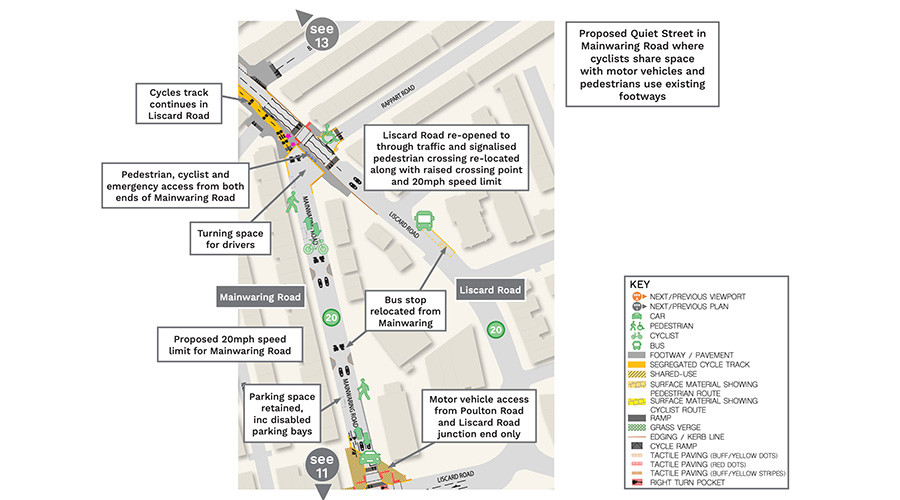
In order to make the pedestrian and cycle route as direct, safe and convenient as possible, it is proposed to use Mainwaring Road to connect between Wheatland Lane and Liscard Road.
It will not be possible to provide a cycle track in Mainwaring Road without removing parking so a Quiet Street is proposed to allow the route to be provided and parking to be retained. The Quiet Street proposal means motor vehicle access will only be possible to and from south end of Mainwaring Road (Poulton Road/Wheatland Lane junction) but pedestrian, cycle and emergency access will be permitted at both ends of Mainwaring Road.
Turning space will be provided at the north end of Mainwaring Road and all parking (including disabled bays) will be retained. Cyclists will use the road in both directions whilst in Mainwaring Road, with small section of shared space at the Poulton Road junction and new cycle track link to Liscard Road at the other end.
A 20mph speed limit is proposed in Mainwaring Road. Liscard Road will be connected to allow through traffic to use it, but a 20mph limit is proposed to the Poulton Road junction.
The existing pedestrian crossing will be relocated to Liscard Road, with the crossing raised to help keep vehicle speeds low. Bus services using Mainwaring Road will divert to Liscard Road with the existing bus stop on Mainwaring Road relocated a short walk away on Liscard Road.
What do you think? Have your say
Have your say on these proposals or any part of the Birkenhead to Liscard route by visiting our consultation website by 4 December.
You can also see larger versions of the maps from this article under the Documents section of the consultation page.